Tennessee Landforms -- waterfalls| WGS84 |
| 36.150000 | -85.426300 |
| 36° 9'N | 85° 25.578'W |
| 36° 9' 0"N | 85° 25' 34.7"W |
| 16S 641570E 4001733N |
| convert to NAD27 |
Hidden Hollow Falls 20'
Waypoint: PUF004 36.150000,-85.426300
County: Putnam landforms of Putnam county
popup list of
nearby landforms (mileage, bearing)
MAPS
Select one of the following maps to display this waypoint (WGS84).
GPS
Remarks:
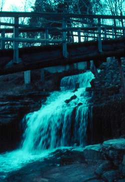 Photo by Gregory Plumb, Author of
Waterfalls of Tennessee
Photo by Gregory Plumb, Author of
Waterfalls of Tennessee
Tennessee landforms
home
arches
waterfalls
rocks
peaks
balds
sinks
lakes
regions
county
GSMNP landforms (TN/NC)
BSF landforms (TN/KY)
or nearby
lookout towers
Chuck Sutherland's www.tnlandforms.com the future (2024)
 ©
Tom Dunigan
©
Tom Dunigan