Tennessee Landforms -- arches and natural bridges| WGS84 |
| 36.473750 | -84.841060 |
| 36° 28.425'N | 84° 50.464'W |
| 36° 28' 25.5"N | 84° 50' 27.8"W |
| 16S 693423E 4038663N |
| Location uncertain. |
| convert to NAD27 |
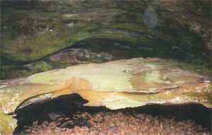
Laurel Fork Arch? 6x2
Waypoint: FEA049 36.473750,-84.841060
County: Fentress landforms of Fentress county
Locale: Big South Fork
NABSQNO 16S-6934XX-40386XX
popup list of
nearby landforms (mileage, bearing)
MAPS
Select one of the following maps to display this waypoint (WGS84).
GPS
Remarks:
Reference/photo: Vic Fife
small arch in rock shelter at base of bluff along Laurel Fork, downstream from Incised Meander arch.
Tennessee landforms
home
arches
waterfalls
rocks
peaks
balds
sinks
lakes
regions
county
GSMNP landforms (TN/NC)
BSF landforms (TN/KY)
or nearby
lookout towers
Chuck Sutherland's www.tnlandforms.com the future (2024)
 ©
Tom Dunigan
©
Tom Dunigan