Click here for map or Google map
Description: The Chuck Swan Wildlife Management Area occupies 24,444 acres on the Central Peninsula on the east shores of Norris Lake, the confluence of the Powell and Clinch rivers. The karstic area consists of rolling gravel and dirt roads through pine and hardwood forests with numerous sinkholes, springs, and several caves. The Main Forest Rd. (10 miles) is wide packed gravel and bisects the peninsula along Dividing Ridge, but TWRA says this road is not open to bicyclists, horses, or ATVs. There are numerous dirt roads looping off the Main Forest Rd. as well as spurs down to the lake (1020') and picnic areas. There are several old cemeteries, some dating to the early 1800's (Lost Cr. Cemetery). The major roads are named and marked at intersections. Most of the loops are fairly level, though the Big Spring/Oaks Chapel loop has some steep sections.
TWRA's controversial "daylighting" of roads has reduced the "quality" of riding through the forests. To reduce road maintenance costs, TWRA is clearcutting the road ways in 75' wide swaths and putting down 2" rock on the secondary spurs.
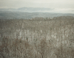
Winter picture (40K) from fire tower (1665.6') looking north over Long Hollow Rd. High point (1673.5') at fire tower, 36.37211,-83.89318 and Union County's deepest sinkhole (82') at 36.324493,-83.956961