6. Melton Lake Greenway
Description:
This multiuse paved greenway runs along the western shore of Melton Lake.
With both flat and steep sections, it is used year-round.
Ducks and geese are common sights.
Trail surface:
Paved (8 to 10 ft wide)
Elevation: 800' to 900'
Difficulty: Easy to moderate
Handicap Access: Yes, except mile 2
Distance:
5.7 miles (as of 2012)
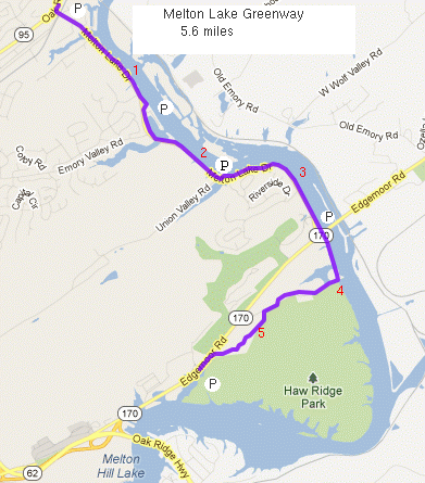
Main Entrances:
Melton Lake Dr at these locations: Oak Ridge Turnpike (Elza Gate Park, mile 0.0),
Oak Ridge Marina (mile 1.3), Union Valley/River Run Blvd (mile 2.25), Edgemoor Rd (mile 3.4), Old Edgemoor Rd (limited parking), and west entrance of Haw Ridge Park (mile 5.7).
Uses:
Walk/jog, pets, bicycles, skates/rollerblades. NO horses, skateboards,
or motorized vehicles
see Google map
Map
legend/rules
Cumulative climb 300' (north to south),
climb at mile 2.5 is 70' (8%/-13%
grade), see
elevation profile,
see biking info.
The greenway parallels Oak Ridge's renowned
rowing venue and runs along
the north face of Haw Ridge park (30 miles of trails).
In 2005, the city received a grant of $650,000 to extend Melton Lake
Greenway south under the bridge to Old Edgemoor Road, and then
down Old Edgemoor Road and Edgemoor Road to the west
entrance of Haw Ridge Park.
This Phase IV work extends the paved greenway
by about 2.2 miles (map).
Survey work began in March, 2008.
Construction began in June, 2011 and was complete in the spring of 2012.
This provides access to the trails of
Haw Ridge Park.
The section along Haw Ridge (miles 4 to 5.7) will be closed for three weekends
in the fall for deer hunts.
GreenwaysOakRidge.org
Greenway maps:
map index
North Ridge
Cedar Hill
Pine Grove
Emory Valley
Gallaher Bend
Melton Lake
Big Turtle
Worthington
North Boundary
Wildflower
Haw Ridge
Black Oak Ridge
Google map
Greenways Oak Ridge home