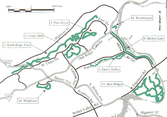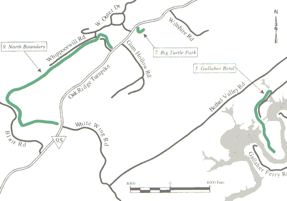

| Greenway | Miles | Walk/ jog | Pets | Bicycle | Skates/ rollerblades | Horseback riding |
| 1. North Ridge Trail | 7.7 | Y | Y | N | N | N |
| 2. Cedar Hill | 2.5 | Y | Y | N | N | N |
| 3. Pine Grove | 1.2 | Y | Y | N | N | N |
| 4. Emory Valley | 3.1 | Y | Y | Y | Y | N |
| 5. Gallaher Bend | 4.5 | Y | Y | Y | N | N |
| 6. Melton Lake | 5.6 | Y | Y | Y | Y | N |
| 7. Big Turtle Park | 0.8 | Y | Y | N | N | N |
| 8. Worthington | 0.7 | Y | Y | N | N | N |
| 9. North Boundary | 14 | Y | Y | Y | N | N |
| 10. Wildflower | 0.8 | Y | Y | N | N | N |
| 11. Haw Ridge | 28+ | Y | Y | Y | N | N |
| 12. Black Oak Ridge | 13.7 | Y | N | Y | N | N |


★ Google map/image/topo of trails and trailheads or iPhone map and trailhead/junction GPS data
Credits
These web pages were produced from the Greenways Trail Maps brochure
published in early 2003 by Sig Christensen and Susan Donnelly
of Greenways Oak Ridge.
Maps were produced from GIS/GPS data provided by Sam Kitchings.
The Greenways Oak Ridge project is a volunteer effort and works
closely with the
Recreation and Parks Department of the City of Oak Ridge.
In 2002 the Greenways officers were:
To learn more and volunteer, please visit the Greenways Oak Ridge home page.