Description: The Tsali (SAH-lee) trail system is a beautiful but heavily used set of single tracks that follows the shore of Fontana Lake. The Smoky Mountains provide magnificent panoramas across the lake to the north. The trails are well marked, so navigation should not be a problem. The original Tsali trail was a horse trail. The Forest service and volunteers developed additional trails (Mouse Branch and Thompson) in the last few years to separate the horse and bike traffic. The current schedule permits bikes on the Tsali loops on Sunday, Monday, Wednesday, and Friday. On the other days, bikes are permitted on the Thompson and Mouse Branch trails. Check the signs at the trail heads for current access restrictions, also see Tsali info, or or Tsali trail brochure, or here, or you might check with the Nantahala Outdoor Center.
Tsali Knobscorcher mountain bike race GPS track/elevation profile.
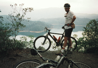
![]() Classic Tsali picture (53K) from overlook.
Classic Tsali picture (53K) from overlook.
A trail fee of $2/day ($15/year) is now required. For further information
contact:
Cheoah Ranger District (NC National Forests)
1133 Massey Branch Road
Robbinsville, NC 28721
828-479-6431
More maps and waypoints for the nearby Great Smoky Mountain Naional Park