Click here for map or 3-D map (45K) or Google map or view aerial image (zoom and pan).
Description: The eastern edge of the Great Smoky Mountains National Park has some steep dirt roads, including some forest service roads of Pisgah National Forest. The roads are packed gravel/dirt climbing through hardwood forests with views of the Pigeon River gorge and Appalachians. This area of the Park is less developed and less crowded. Camping is available in the Park's Big Creek and Cataloochee campgrounds.
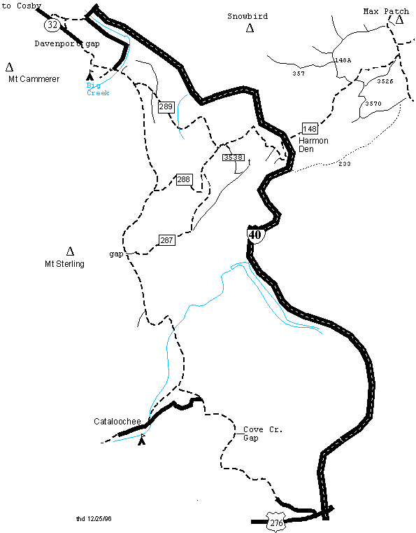
The Mt Sterling road runs 23 miles from Big Creek to Cove Creek (US 276). Two miles from the Waterville exit, Mt Sterling road climbs from Big Creek (1555') along the eastern edge of the Park. At mile 1 (1910'), Forest Service Road (FS) 289 drops off to the left. At mile 4.5 (2960'), FS 288 joins from the left, and the Mt Sterling Rd enters the Park. At mile 7, the road crests at Mt Sterling Gap (3888'), a jeep road climbs east to FS 287. Mt Sterling Rd descends to Cataloochee Creek (2480') at mile 12. The road climbs to 2820' at mile 14 where a road to the right descends into the Cataloochee valley. The Mt Sterling road continues to climb to Sal Patch Gap (mile 16, 3580') where it intersects the paved road that descends into the Cataloochee valley. Mt Sterling road continues to climb to Cove Creek Gap (mile 18, 4070') and leaves the Park. The road descends into civilization and pavement and joins US 276 at I40 (2580').
The orphaned Cataloochee pavement starts at Sal Patch Gap (3580') and descends into the valley. At mile 3 the pavement crosses Cataloochee Creek (2600') and is joined from the right by the gravel road coming 2 miles from Mt Sterling Rd. The pavement continues up the valley along the creek and past the campground. The road passes by several old settlements before turning to gravel (mile 5) and terminating at mile 6 (2860'). The loop is 7 miles with a cumulative climb of 1000'.
FS 288 (2960') winds its way for 12 miles around and down Longarm Mountain to the Harmon Den Exit (1960'). At mile 3.5, FS 287 climbs off to the right and up to Longarm ridge (3600') in 2.7 miles. From the ridge, a jeep road goes left 2 miles and joins FS 3538. To the right, FS 287 climbs 2.7 miles to Mt Sterling Gap. At mile 5 (2940') on FS 288, FS 289 descends to the left to Mt Sterling Creek, and FS 3538 climbs to the right up to the radio tower (3628'). At mile 6.5, gated FS 453 climbs to the right. At mile 7.9, a jeep road climbs up Hicks Creek. FS 288 continues its descent to I40 with dramatic views of the Pigeon River 1000 feet below.
You can also ride the Tobes Creek loop (5.4 miles, cumulative climb 620'). From the Big Creek intersection (1555'), climb right to Davenport Gap (2040') and then 0.8 miles along TN 32 to the gravel on the right just past Phillips Cemetery. Descend down to the Pigeon (1370'). Turn right and follow the road back up the river to the Mt Sterling Rd intersection.
Other loops are the FS 289 loop that descends 1.8 miles down to Mt Sterling Creek (1980', wet crossing) and up 2.2 miles to FS 288. The loop is 12 miles with a cumulative climb of 2300'. It is easier to descend from 288 down 289 to the creek crossing. There are other side roads off of 289 (mile 0.9), including one that descends to Big Creek. The FS 287/288/Mt Sterling Gap loop is 11.4 miles and a cumulative climb of 1300'.
From I40 (Harmon Den, 1960'), the gravel road (FS 148) continues NE up Cold Springs Creek. At mile 3.2 (2750'), FS 148A enters from the left at a parking area. From here you can ride an 10 mile loop, cumulative climb 1550'. Ride up FS 148 3.4 miles to Fines Creek Rd, NC 1181 (3780'), turn left(N) up the ridge 1.5 miles to where the AT (white blazes) crosses the road (4280'). The dirt road to Brown Gap drops off to the left. (You can ride another 0.25 miles up to the Max Patch bald trail head (4320') and hike the 0.6 miles to the top of the bald (4629').) From the AT crossing, descend the jeep road 4.1 miles to Brown Gap (3500'), where you descend FS 148A 1.1 miles back to the parking area. There is a loop from Brown Gap to Deep Gap (2910') via FS 357 (mile 5.8). FS 357 runs 8 or more (?) miles along a bench on the south face of of Snowbird mountain starting on FS 148A just below Brown Gap. It offers good views into the Pigeon River Valley. There are numerous jeep roads (some on private land) on the Tennessee side of Snowbird mountain. The gravel road that takes you to the Max Patch parking area continues north and descends 12 miles to TN 107, passing through Lemon Gap and past Round Mountain campground. You can ride FT 135 2 miles up to Walnut Mountain. You can ride FS 96 to Rattlesnake Gap and beyond, or climb up to Round Mountain from FS 3242.
There are other bikeable forest service roads off of FS 148. From the picnic area (mile 3.3, 2780'), FS 3526 climbs toward Robert Gap and rejoins FS 148. Also from the picnic area, FS 3570 winds its way 7 miles up to Meadow Fork Gap (3950') on NC 1181. Just below the gap, FS 233 (4 WD jeep road) descends 6 miles along Hurricane Creek to I40 (2000').
From the Hartford exit (Exit 447), you can ride a 19 mile loop up to the Stone Mountain tower ( Hall Top). Park at Mill Creek road (1260') on your left, ride the pavement up Big Creek Road 3.7 miles to a left at Raven Branch and then a left at mile 4.1 and then a left at mile 4.5 up gravel Hall Top Road (FR 207). (The lower area is residential, and there are lots of dogs!@!) Climb 5 miles to the tower (3610'). Stone Mountain trail (#9), departs from the cliff area 0.2 miles before the tower and descends 2.5 miles to FS 110 (spur trail out to white rocks at Buzzard Roost). FS 110 drops 3.5 miles along Mill Creek. Follow Mill Creek Rd 1.3 miles back to Big Creek Road. In 2020, CNF announces plan to build 20 to 50 miles of mountain bike trails on Hall Top (Stone Mountain), $6 million project.
For more information on mountain biking in the Great Smoky Mountains National Park, see the Rich Mtn/Parson Branch page.
More maps and waypoints for the Smokies