The Cherokee National Forest lies along the western slopes of the Appalachians in East Tennessee. The Forest Service roads are gravel and dirt and are open to bicycles -- even the gated gravel roads. Most roads are graded, but there are some designated "off-road vehicle/4WD" roads that are rougher and steeper. Horse trails are also open to mountain bikers. There are a few single-track trails open to bicycles, but bicycles are not permitted on hiking trails or in the Gee Creek Wilderness. Check with the Forest Service office (423-476-9700) for current access restrictions.
Description: Starr Mountain provides several loops along gravel roads and horse trails with views both to the south and to the west. The trails are through hardwoods and some southern pine.
The Chestnut Mountain loop (21 miles) begins at the Lost Corral parking area, just west of the Gee Creek Campground on county road 27, off of US 411, 6 miles south of Etowah. From the parking area (750'), ride the 4WD FR 2004 8 miles to Iron Gap on FR 44 (see map). The rutted jeep road climbs steadily for 2.6 miles to 1820' where it curls around Chestnut Mountain. The jeep road levels (some mud holes in the rainy season) before climbing to an overlook at mile 5.3 (1920') with views to the southeast. At mile 8 (1880') the 4WD road joins gravel FR 44 at Iron Gap. Turn right on FR 44 and descend 4.5 miles to TN 315 (950'). Turn right on the pavement and ride 1.9 miles through Springtown to County Rd 27 (Maggies Mill). Ride down 0.2 miles where you leave the pavement heading north on the gravel road. The gravel road eventually heads west along Spring Creek to its junction with the Hiwassee River.
Other loops include FR 44 from TN 315 back County Rd. 655. FR 44 climbs from TN 315 (950') past Iron Gap (mile 4.5) to 2000' at its juncture with FR 297 (297 is gated but bikable, mile 6.6) before descending back to CR 655 and out to TN 315 (mile 13.1). You can turn south on 315 and return 2.6 miles to your starting point. From FR 44 there are bikable horse trails along Hogback Ridge (3.1 miles)
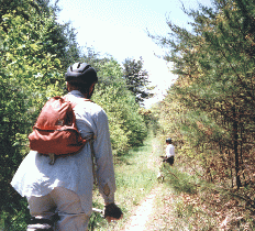
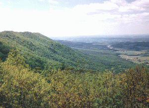
The Starr Mountain loop (16.5 miles, 2040' cumulative climb) can be started from mile 6.6 (2000') of FR 44, you climb north along old FR 297 (Starr Mountain horse trail 120, picture,43K) along the backbone of Starr Mountain (2300'). At mile 3.5, a gravel road climbs steeply to the left 0.25 miles to the fire tower (2200') offering views to the west (picture, 44K). At mile 7.5 (2040'), 297 joins FR 220. To the left, the dirt road descends 2.3 miles to TN 39 (1090', 8 miles from Etowah). Turn right along 220 til it joins FR 44 at mile 13.5 (1580'). Turn right and climb 3 miles back to the trail head. This loop can be shortened with the Bullet Creek horse trail (2.7 miles).
More mountain biking in the Cherokee National Forest can be found to the south ( Ocoee/Oswald Dome ) and to the north ( Tellico).
A history of
Starr Mountain and locations of other
Tennessee lookout towers.