Bicycling in the Great Smoky Mountains National Park is allowed on any park road which is open to vehicle traffic. However, due to steep terrain, narrow road surfaces and heavy vehicle traffic, many roads are not well suited to bicycle travel.
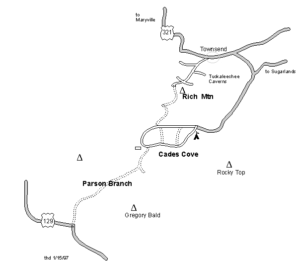
Bicycles are prohibited on park trails, with four exceptions. The trail between Gatlinburg and Park Headquarters and the trail between Cherokee and the Oconaluftee Visitor Center may be ridden. In addition, the graveled portions of the Indian Creek and Deep Creek trails (north of Bryson City, North Carolina) may be ridden. Those roads which are closed to motor vehicles during the winter ( Rich Mtn, Parson Branch, Balsam Mtn, Clingmans Dome, Forge Creek, Heintooga-Roundbottom, Little Greenbrier, and Upper Tremont) are open to bicycles year round as is the unfinished portion of the Foothills Parkway between Walland and Wears Valley (maybe not after 1998). In addition, the Mt. Sterling Road is an extensive backcountry dirt road joining Cataloochee to Big Creek. Visit park page for current road closures.
The Cades Cove loop road, an 10.4 mile one way road, is a popular bicycling area (see mileage/elevation profile for loop run or here). The loop is paved and gently rolling (1000' cumulative climb) with many points of interest along the way. Bicycles may be rented nearby at the Cades Cove campground store. In 2020, the loop road is closed to motor vehicle traffic all day Wednesdays from June 17 to September 30th, see ( schedule). The loop road is closed to motor vehicle traffic at sunset each evening, so another nice variation under a full moon is a moonlight ride.
Also see NPS's Great Smoky Mountains National Park page.
Click here for map or 3-D map (40K).
Description: From Rich Mountain Gap ride up the gravel Rich Mountain Road south 3.3 miles to a view of Cades Coves, descend 3.4 miles to the Cades Coves loop road, proceed west on the pavement to the Visitor Center at the southwest corner of the loop. Take the gravel road south to the Parson Branch gate ('bout 2 miles). Climb the gravel Parson Branch Road through the rhododendron tunnels to the Gregory Bald trail head (3.3 miles), then descend to 129 (another 5 miles). This descent has many creek crossings. Whew! Now turn around and ride back to the Cades Coves loop. Turn right on the Cades Coves loop road. You can take Hyatt Lane or Sparks Lane as shortcuts across the Cove to the Rich Mountain road. Cumulative climb for this roundtrip is about 6000'.
Or ride from the park boundary at Rich Mountain into the Cove (6.8 miles) and then ride the loop, and back out -- total 24 miles. See GPS track/elevation profile.
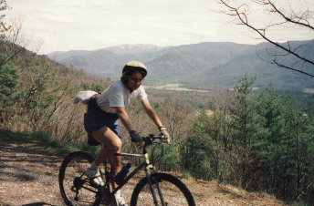
Picture (59K) of Cades Cove from Rich Mountain road.
More maps and waypoints for the Smokies