The area is usually closed February through March and at various times in the fall and spring for hunts. See TWRA hunt schedules for April and May closure dates for turkey hunts also see TWRA WMA hunt schedule.
Click here for map.
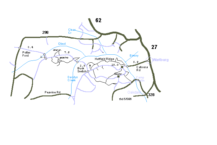
Description: The Catoosa Wildlife Management Area occupies 80,000 acres on the Cumberland Plateau. The area is administered and owned by the Tennessee Wildlife Resources Agency, funded by hunters and fisherman. Catoosa is laced with gravel and dirt roads and some single track. Numerous whitewater streams ( Obed -- National Wild & Scenic River, Emory, Clear Creek, Daddys Creek, Whites Creek, and Crab Orchard Creek) cut canyons and gorges through the sandstone. There are numerous spur trails to overlooks on the sandstone cliffs and a few loops.
TWRA's controversial "daylighting" of roads has reduced the "quality" of riding through the forests. To reduce road maintenance costs, TWRA is clearcutting the road ways in 75' wide swaths and putting down 2" rock on the secondary spurs. The pine beetle is also wreaking havoc with the remaining forest trails.
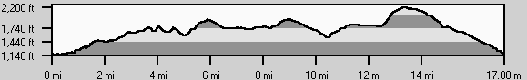
A nice 18.0 mile gravel loop starts at the Catoosa checking station winds around to Buck Switch then on up to the Bicolor intersection (2160') and then down to Island Creek and back to your starting point. (cumulative climb 2000', see GPS track)
At a 4-way about a mile west (elevation 1760') of Bicolor, you can also take a nice ATV track to the northeast 2.9 miles across Island Creek (1120') to the Catoosa checking station. At mile 1.9 (1460') at a 4-way, an old ATV track climbs to the "Virginia Pine Lot", 0.7 (1800') miles east of Bicolor. A TWRA spur also goes south 1.9 miles to the main gravel.
On Catoosa/Nemo Rd. (1850') just a mile east of the Buck Switch junction with the road to Daddy's Creek (or about 8 miles from Nemo Bridge), there is a road that leads north 0.5 miles to the Pilot Knob fire tower (2050'). Halfway up this road, an ATV track heads northeast 8.4 miles along Hatfield Mountain and descends steeply to the campground at Nemo bridge (860'), or you can take a right after 2.7 miles and exit back to Nemo Rd, or at mile 4.5 you can take a right and descend 3 miles to Nemo Rd (the gravel road just above the campground gravel road).
At mile 1.5 along Hatfield Mountain, a left descends (gnarly) .7 miles and then heads west up Turkey Creek. At mile 3, you cross Turkey Creek and climb back to the main gravel at mile 4.6. Mile 6.7 brings you back to the parking area with a cumulative climb of 830' for the loop.
There are several ATV trails southeast of the gravel between Island Creek and the Bicolor checking station, some interconnecting with the jeep roads to Camp Austin. Clark Cemetery ATV trail descends 2.2 miles from Camp Austin road to White Oak Rd., then west 4.5 miles to Bicolor, then east 2.8 miles to close the 10 mile loop.
To the west, there is a nice 8 mile loop along the east side of Otter Creek, and loops in the vicinity of Peavine mountain.
Catoosa history and landforms and hike the Obed section of the Cumberland Trail (GPS track).
Catoosa high point 2480' at 35.99204 -84.72519