1. North Ridge Trail Greenway
Description:
This National Recreation Trail, designated in 1973, traverses
ridge-side woodland and creeks.
The trail is mostly sheltered from house and roads.
A wide variety of wildlife and native
plants inhabit the area.
The main trail is blazed white, the Delaware Loop is blazed red,
one side trail is blazed yellow, and accesses are blazed blue.
Trail surface:
Natural wooded path
Elevation: 830' to 1160'
Difficulty: Difficult (1850' cumulative climb),
elevation profile
Handicap Access: No
Distance:
Main trail 7.7 miles one way; ancillary trails, 2.6 miles
Main Entrances:
Endicott Ln; Englewood Ln; Outer Dr at Georgia Ave or Delaware Ave;
Orchard Ln; Walker Ln; Wedgewood Rd; Illinois Ave at W. Outer Dr;
W. Outer Dr (west of #852)
Uses:
Walk/jog, pets
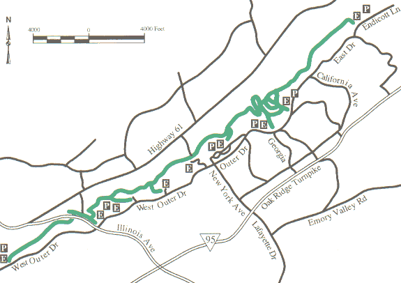
Map
legend/rules
Here is an
older map with a little more detail or try the
Google
map.
TCWP's
trail
map
and
North Ridge Trail trail stewardship info.
The trail rolls up and down the hollows of the north ridge of Oak Ridge,
not far from the city boundary.
You will have a cumulative climb of about 1850', see
elevation profile
or this
GPS track file or another GPS
track file
or here.
There are two
small arches
(rock ribs) along the trail and a few small sinkholes.
Here is
facebook page for North Ridge Trail.
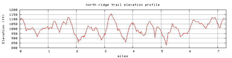
Endicott to Mississippi, 7.7 miles, cumulative climb 1850'
Report downed trees or other trail problems
here or on facebook page.
GreenwaysOakRidge.org
Greenway maps:
map index
North Ridge
Cedar Hill
Pine Grove
Emory Valley
Gallaher Bend
Melton Lake
Big Turtle
Worthington
North Boundary
Wildflower
Haw Ridge
Black Oak Ridge
Google map
Greenways Oak Ridge home