11. Haw Ridge Trails
Description:
This greenway provides a mostly wooded series of trails of varying
difficulty, many suitable for mountain biking, in an
undeveloped area with waterfront access.
More details and maps at HawRidge.org.
Trail surface:
Natural wooded path
Elevation: 795' to 1157'
Difficulty: Moderate to difficult
Handicap Access: No
Distance:
28+ miles
Main Entrances:
Edgemoor Rd. 0.1 miles east of parking area;
Old Edgemoor Rd opposite Park Meade Dr;
Old Edgemoor shoulder east of Life Development Center
Uses:
Walk/jog, pets, bicycles (No horses. No motorized vehicles.)
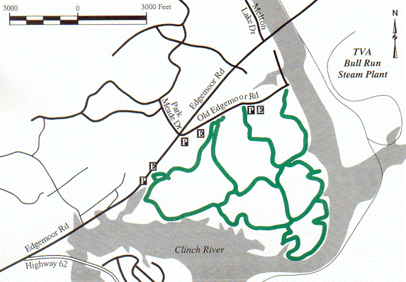
Map
legend/rules
The map above is only "suggestive" because there are more than 28 miles
of trails in Haw Ridge Park. See google trail map
or visit the
Haw Ridge Park web page for
detailed trail maps and geology and wildflower information.
Phase IV of the Melton Lake
Greenway was begun in June, 2011.
It extends the greenway along the north edge of Haw Ridge Park.
Beware.
This area is closed for deer hunts three weekends each fall,
please check the park web page
for exact dates.
GreenwaysOakRidge.org
Greenway maps:
map index
North Ridge
Cedar Hill
Pine Grove
Emory Valley
Gallaher Bend
Melton Lake
Big Turtle
Worthington
North Boundary
Wildflower
Haw Ridge
Black Oak Ridge
Google map
Greenways Oak Ridge home