Greenways Oak Ridge Google map
Greenways Oak Ridge iPhone map
marker:
Zoom&Center:
Big Turtle Park
Black Oak Ridge
Cedar Hill
Emory Valley
Gallaher Bend
Haw Ridge
Melton Lake
North Boundary
North Ridge
Pine Grove
Wheat
Wildflower
Worthington
 goto my location
Enter street,city,state or zip code or lat,-lon (dd.ddd)
(for lat/lon or UTM or NAD27 use this)
- You can drag map with left button, right-click to add draggable markers
- click on icon to get name and clickable link
- Try Google Earth with the
greenways KML file gw.kmz
- Greenways GPS data trailheads
- non-google leaflet map or
alternate google map
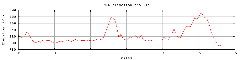
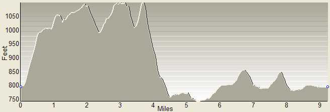
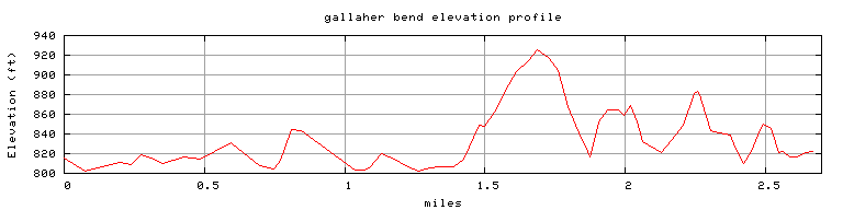
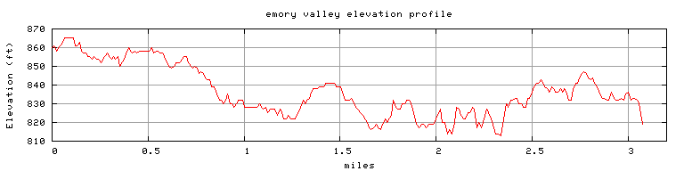
Δ Elevation profiles:
North Ridge
or
Melton Lake
or
North Boundary
or
Gallaher Bend
or
Emory Valley
Δ Highest point on greenways is along
North Ridge trail (1154')
Δ highest point in Oak Ridge,
Melton Hill (1356'), ORNL reservation
GreenwaysOakRidge.org
Greenway maps:
map index
North Ridge
Cedar Hill
Pine Grove
Emory Valley
Gallaher Bend
Melton Lake
Big Turtle
Worthington
North Boundary
Wildflower
Haw Ridge
Black Oak Ridge
Greenways Oak Ridge home
Pellissippi Blueway
Arboretum
Heritage Center
trails K-25, East Fork Poplar Creek trail
City's
greenway maps
Explore Oak Ridge
Tom Dunigan TNlandforms.US