Tennessee lookout towers | WGS84 |
| 35.14909 | -87.7427 |
| 35° 8.945'N | 87° 44.562'W |
| 35° 8' 56.7"N | 87° 44' 33.7"W |
| 16S 432350E 3889830N |
| convert to NAD27 |
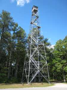
McGlamerys
Waypoint: WYT004 35.14909,-87.7427
County: Wayne
Elevation: 1043'
Info: 7-24 standing
popup list of
nearby towers (mileage, bearing)
or
nearby landforms
MAPS
Select one of the following maps to display this waypoint (WGS84).
GPS
Remarks:
1955 photo
Tennessee lookout towers

BSF landforms (TN/KY)
GSMNP landforms (TN/NC)
Tennessee landforms
home
arches
waterfalls
rocks
peaks
balds
sinks
lakes
regions
county
 ©
Tom Dunigan
©
Tom Dunigan