Tennessee lookout towers | WGS84 |
| 36.0492 | -86.3163 |
| 36° 2.952'N | 86° 18.978'W |
| 36° 2' 57.1"N | 86° 18' 58.7"W |
| 16S 561582E 3989622N |
| convert to NAD27 |
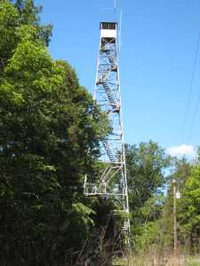
Hurricane
Waypoint: WLT001 36.0492,-86.3163
County: Wilson
Elevation: 794'
Info: 6-4 standing
popup list of
nearby towers (mileage, bearing)
or
nearby landforms
MAPS
Select one of the following maps to display this waypoint (WGS84).
GPS
Remarks:
history
Tennessee lookout towers

BSF landforms (TN/KY)
GSMNP landforms (TN/NC)
Tennessee landforms
home
arches
waterfalls
rocks
peaks
balds
sinks
lakes
regions
county
 ©
Tom Dunigan
©
Tom Dunigan