Tennessee lookout towers | WGS84 |
| 36.3487 | -88.731 |
| 36° 20.922'N | 88° 43.86'W |
| 36° 20' 55.3"N | 88° 43' 51.6"W |
| 16S 344672E 4024016N |
| convert to NAD27 |
Hyndsver
Waypoint: WET002 36.3487,-88.731
County: Weakley
Elevation: 503'
Info: 9-1 standing
popup list of
nearby towers (mileage, bearing)
or
nearby landforms
MAPS
Select one of the following maps to display this waypoint (WGS84).
GPS
Remarks:
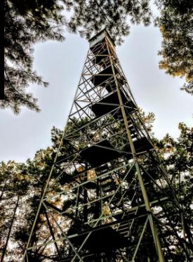 courtesy of Mary Helen Maddox
Tennessee lookout towers

BSF landforms (TN/KY)
GSMNP landforms (TN/NC)
Tennessee landforms
home
arches
waterfalls
rocks
peaks
balds
sinks
lakes
regions
county
 ©
Tom Dunigan
©
Tom Dunigan