Tennessee lookout towers | WGS84 |
| 36.6124 | -87.9807 |
| 36° 36.744'N | 87° 58.842'W |
| 36° 36' 44.6"N | 87° 58' 50.5"W |
| 16S 412299E 4052324N |
| convert to NAD27 |
Barrow
Waypoint: STT001 36.6124,-87.9807
County: Stewart
Elevation: 650'
Info: 6-17 standing
popup list of
nearby towers (mileage, bearing)
or
nearby landforms
MAPS
Select one of the following maps to display this waypoint (WGS84).
GPS
Remarks:
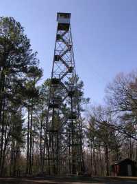 in Land Between the Lakes
photo
Tennessee lookout towers

BSF landforms (TN/KY)
GSMNP landforms (TN/NC)
Tennessee landforms
home
arches
waterfalls
rocks
peaks
balds
sinks
lakes
regions
county
 ©
Tom Dunigan
©
Tom Dunigan