Tennessee lookout towers | WGS84 |
| 36.5022 | -84.5512 |
| 36° 30.132'N | 84° 33.072'W |
| 36° 30' 7.9"N | 84° 33' 4.3"W |
| 16S 719316E 4042441N |
| convert to NAD27 |
Smith Knob
Waypoint: SCT004 36.5022,-84.5512
County: Scott
Elevation: 1654'
Info: GB2628 2-20 standing
popup list of
nearby towers (mileage, bearing)
or
nearby landforms
MAPS
Select one of the following maps to display this waypoint (WGS84).
GPS
Remarks:
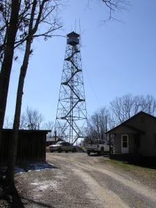 aka, Oneida tower
Tennessee lookout towers

BSF landforms (TN/KY)
GSMNP landforms (TN/NC)
Tennessee landforms
home
arches
waterfalls
rocks
peaks
balds
sinks
lakes
regions
county
 ©
Tom Dunigan
©
Tom Dunigan