Tennessee lookout towers | WGS84 |
| 36.5923 | -84.5581 |
| 36° 35.538'N | 84° 33.486'W |
| 36° 35' 32.3"N | 84° 33' 29.2"W |
| 16S 718444E 4052422N |
| convert to NAD27 |
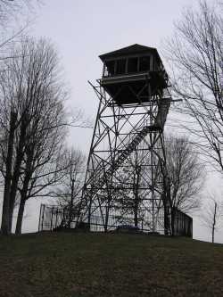
Slaven Knob
Waypoint: SCT003 36.5923,-84.5581
County: Scott
Elevation: 1509'
Info: GB2625 2-21 standing
popup list of
nearby towers (mileage, bearing)
or
nearby landforms
MAPS
Select one of the following maps to display this waypoint (WGS84).
GPS
Remarks:
Tennessee lookout towers

BSF landforms (TN/KY)
GSMNP landforms (TN/NC)
Tennessee landforms
home
arches
waterfalls
rocks
peaks
balds
sinks
lakes
regions
county
 ©
Tom Dunigan
©
Tom Dunigan