Tennessee lookout towers | WGS84 |
| 36.53037 | -85.10562 |
| 36° 31.822'N | 85° 6.337'W |
| 36° 31' 49.3"N | 85° 6' 20.2"W |
| 16S 669595E 4044446N |
| convert to NAD27 |
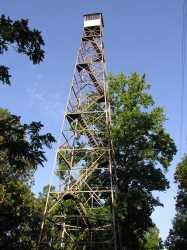
Regan Knob
Waypoint: PIT001 36.53037,-85.10562
County: Pickett
Elevation: 1642'
Info: 4-5 standing
popup list of
nearby towers (mileage, bearing)
or
nearby landforms
MAPS
Select one of the following maps to display this waypoint (WGS84).
GPS
Remarks:
Tennessee lookout towers

BSF landforms (TN/KY)
GSMNP landforms (TN/NC)
Tennessee landforms
home
arches
waterfalls
rocks
peaks
balds
sinks
lakes
regions
county
 ©
Tom Dunigan
©
Tom Dunigan