Tennessee lookout towers | WGS84 |
| 36.29128 | -85.13875 |
| 36° 17.477'N | 85° 8.325'W |
| 36° 17' 28.6"N | 85° 8' 19.5"W |
| 16S 667140E 4017865N |
| convert to NAD27 |
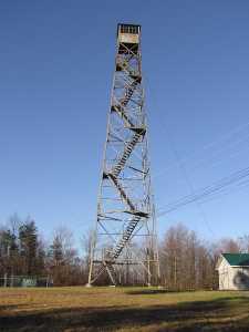
Twinton
Waypoint: OVT004 36.29128,-85.13875
County: Overton
Elevation: 1863'
Info: 4-13 standing
popup list of
nearby towers (mileage, bearing)
or
nearby landforms
MAPS
Select one of the following maps to display this waypoint (WGS84).
GPS
Remarks:
Tennessee lookout towers

BSF landforms (TN/KY)
GSMNP landforms (TN/NC)
Tennessee landforms
home
arches
waterfalls
rocks
peaks
balds
sinks
lakes
regions
county
 ©
Tom Dunigan
©
Tom Dunigan