Tennessee lookout towers | WGS84 |
| 36.0708 | -84.5466 |
| 36° 4.248'N | 84° 32.796'W |
| 36° 4' 14.9"N | 84° 32' 47.8"W |
| 16S 720942E 3994587N |
| convert to NAD27 |
Lone Mountain
Waypoint: MGT007 36.0708,-84.5466
County: Morgan
Elevation: 1394'
Info: sitting
popup list of
nearby towers (mileage, bearing)
or
nearby landforms
MAPS
Select one of the following maps to display this waypoint (WGS84).
GPS
Remarks:
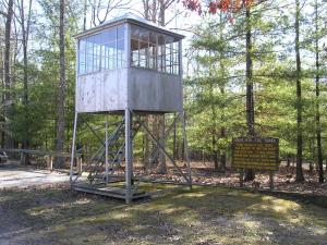
Located in
Lone Mountain state forest,
this exhibit is just the cab relocated from
House Mountain.
Tennessee lookout towers

BSF landforms (TN/KY)
GSMNP landforms (TN/NC)
Tennessee landforms
home
arches
waterfalls
rocks
peaks
balds
sinks
lakes
regions
county
 ©
Tom Dunigan
©
Tom Dunigan