Tennessee lookout towers | WGS84 |
| 36.16279 | -84.8862 |
| 36° 9.767'N | 84° 53.172'W |
| 36° 9' 46"N | 84° 53' 10.3"W |
| 16S 690133E 4004076N |
| convert to NAD27 |
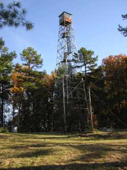
Jones Knob
Waypoint: MGT003 36.16279,-84.8862
County: Morgan
Elevation: 1792'
Info: 2-26 standing
popup list of
nearby towers (mileage, bearing)
or
nearby landforms
MAPS
Select one of the following maps to display this waypoint (WGS84).
GPS
Remarks:
Tennessee lookout towers

BSF landforms (TN/KY)
GSMNP landforms (TN/NC)
Tennessee landforms
home
arches
waterfalls
rocks
peaks
balds
sinks
lakes
regions
county
 ©
Tom Dunigan
©
Tom Dunigan