Tennessee lookout towers | WGS84 |
| 35.76019 | -89.6691 |
| 35° 45.611'N | 89° 40.146'W |
| 35° 45' 36.7"N | 89° 40' 8.8"W |
| 16S 258686E 3960638N |
| convert to NAD27 |
Open Lake
Waypoint: LUT002 35.76019,-89.6691
County: Lauderdale
Elevation: 460'
Info: 9-15 standing
popup list of
nearby towers (mileage, bearing)
or
nearby landforms
MAPS
Select one of the following maps to display this waypoint (WGS84).
GPS
Remarks:
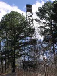
Tom Owen's photo
Tennessee lookout towers

BSF landforms (TN/KY)
GSMNP landforms (TN/NC)
Tennessee landforms
home
arches
waterfalls
rocks
peaks
balds
sinks
lakes
regions
county
 ©
Tom Dunigan
©
Tom Dunigan