Tennessee lookout towers | WGS84 |
| 36.00156 | -83.94479 |
| 36° 0.094'N | 83° 56.687'W |
| 36° 0' 5.6"N | 83° 56' 41.2"W |
| 17S 234562E 3988133N |
| convert to NAD27 |
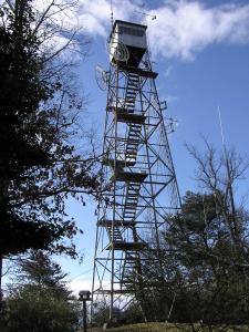
Sharps Ridge
Waypoint: KNT002 36.00156,-83.94479
County: Knox
Elevation: 1355'
Info: GA3549 2-4 standing
popup list of
nearby towers (mileage, bearing)
or
nearby landforms
MAPS
Select one of the following maps to display this waypoint (WGS84).
GPS
Remarks:
weather at the tower
To the east is Knoxville's
highest point 1408'
Tennessee lookout towers

BSF landforms (TN/KY)
GSMNP landforms (TN/NC)
Tennessee landforms
home
arches
waterfalls
rocks
peaks
balds
sinks
lakes
regions
county
 ©
Tom Dunigan
©
Tom Dunigan