Tennessee lookout towers | WGS84 |
| 35.2506 | -85.2194 |
| 35° 15.036'N | 85° 13.164'W |
| 35° 15' 2.2"N | 85° 13' 9.8"W |
| 16S 661995E 3902287N |
| convert to NAD27 |
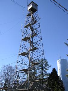
Montlake
Waypoint: HMT001 35.2506,-85.2194
County: Hamilton
Elevation: 1854'
Info: 3-12 standing
popup list of
nearby towers (mileage, bearing)
or
nearby landforms
MAPS
Select one of the following maps to display this waypoint (WGS84).
GPS
Remarks:
Tennessee lookout towers

BSF landforms (TN/KY)
GSMNP landforms (TN/NC)
Tennessee landforms
home
arches
waterfalls
rocks
peaks
balds
sinks
lakes
regions
county
 ©
Tom Dunigan
©
Tom Dunigan