Tennessee lookout towers | WGS84 |
| 35.4351 | -85.7969 |
| 35° 26.106'N | 85° 47.814'W |
| 35° 26' 6.4"N | 85° 47' 48.8"W |
| 16S 609203E 3921961N |
| convert to NAD27 |
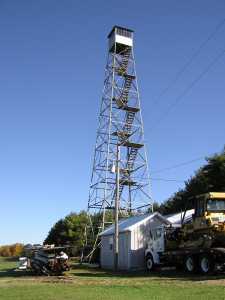
Altamont
Waypoint: GUT001 35.4351,-85.7969
County: Grundy
Elevation: 2031'
Info: 3-21 standing
popup list of
nearby towers (mileage, bearing)
or
nearby landforms
MAPS
Select one of the following maps to display this waypoint (WGS84).
GPS
Remarks:
Tennessee lookout towers

BSF landforms (TN/KY)
GSMNP landforms (TN/NC)
Tennessee landforms
home
arches
waterfalls
rocks
peaks
balds
sinks
lakes
regions
county
 ©
Tom Dunigan
©
Tom Dunigan