Tennessee lookout towers | WGS84 |
| 35.9271 | -82.80495 |
| 35° 55.626'N | 82° 48.297'W |
| 35° 55' 37.6"N | 82° 48' 17.8"W |
| 17S 337166E 3977368N |
| convert to NAD27 |
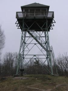
Rich Mountain
Waypoint: GET002 35.9271,-82.80495
County: Greene
Elevation: 3670'
Info: cnf standing
popup list of
nearby towers (mileage, bearing)
or
nearby landforms
MAPS
Select one of the following maps to display this waypoint (WGS84).
GPS
Remarks:
Tennessee lookout towers

BSF landforms (TN/KY)
GSMNP landforms (TN/NC)
Tennessee landforms
home
arches
waterfalls
rocks
peaks
balds
sinks
lakes
regions
county
 ©
Tom Dunigan
©
Tom Dunigan