Tennessee lookout towers | WGS84 |
| 35.2197 | -85.8882 |
| 35° 13.182'N | 85° 53.292'W |
| 35° 13' 10.9"N | 85° 53' 17.5"W |
| 16S 601184E 3897974N |
| convert to NAD27 |
Sewanee
Waypoint: FRT002 35.2197,-85.8882
County: Franklin
Elevation: 2044'
Info: FC1909 5-9 standing
popup list of
nearby towers (mileage, bearing)
or
nearby landforms
MAPS
Select one of the following maps to display this waypoint (WGS84).
GPS
Remarks:
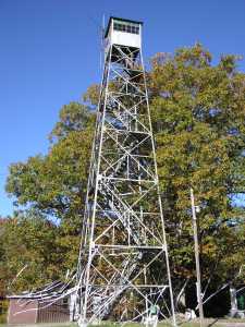
Tom Owen's
photo
Tennessee lookout towers

BSF landforms (TN/KY)
GSMNP landforms (TN/NC)
Tennessee landforms
home
arches
waterfalls
rocks
peaks
balds
sinks
lakes
regions
county
 ©
Tom Dunigan
©
Tom Dunigan