Tennessee lookout towers | WGS84 |
| 35.10029 | -86.11889 |
| 35° 6.017'N | 86° 7.133'W |
| 35° 6' 1"N | 86° 7' 8"W |
| 16S 580306E 3884521N |
| convert to NAD27 |
Rowe Gap
Waypoint: FRT001 35.10029,-86.11889
County: Franklin
Elevation: 1873'
Info: 5-10 removed
popup list of
nearby towers (mileage, bearing)
or
nearby landforms
MAPS
Select one of the following maps to display this waypoint (WGS84).
GPS
Remarks:
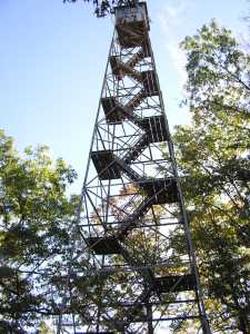 aka Keith Springs
Tennessee lookout towers

BSF landforms (TN/KY)
GSMNP landforms (TN/NC)
Tennessee landforms
home
arches
waterfalls
rocks
peaks
balds
sinks
lakes
regions
county
 ©
Tom Dunigan
©
Tom Dunigan