Tennessee lookout towers | WGS84 |
| 36.3835 | -84.9038 |
| 36° 23.01'N | 84° 54.228'W |
| 36° 23' 0.6"N | 84° 54' 13.7"W |
| 16S 688019E 4028526N |
| convert to NAD27 |
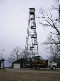
Allardt
Waypoint: FET001 36.3835,-84.9038
County: Fentress
Elevation: 1697'
Info: 4-4 standing
popup list of
nearby towers (mileage, bearing)
or
nearby landforms
MAPS
Select one of the following maps to display this waypoint (WGS84).
GPS
Remarks:
Tennessee lookout towers

BSF landforms (TN/KY)
GSMNP landforms (TN/NC)
Tennessee landforms
home
arches
waterfalls
rocks
peaks
balds
sinks
lakes
regions
county
 ©
Tom Dunigan
©
Tom Dunigan