Tennessee lookout towers | WGS84 |
| 36.1432 | -89.3828 |
| 36° 8.592'N | 89° 22.968'W |
| 36° 8' 35.5"N | 89° 22' 58.1"W |
| 16S 285614E 4002462N |
| convert to NAD27 |
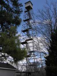
Millsfield
Waypoint: DYT002 36.1432,-89.3828
County: Dyer
Elevation: 515'
Info: 9-12 removed
popup list of
nearby towers (mileage, bearing)
or
nearby landforms
MAPS
Select one of the following maps to display this waypoint (WGS84).
GPS
Remarks:
 2008
2008
county high point, now a microwave tower ...
Tennessee lookout towers

BSF landforms (TN/KY)
GSMNP landforms (TN/NC)
Tennessee landforms
home
arches
waterfalls
rocks
peaks
balds
sinks
lakes
regions
county
 ©
Tom Dunigan
©
Tom Dunigan