Tennessee lookout towers | WGS84 |
| 35.99696 | -85.85481 |
| 35° 59.818'N | 85° 51.289'W |
| 35° 59' 49.1"N | 85° 51' 17.3"W |
| 16S 603219E 3984219N |
| convert to NAD27 |
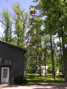
Smithville
Waypoint: DKT001 35.99696,-85.85481
County: DeKalb
Elevation: 1145'
Info: 4-25 standing
popup list of
nearby towers (mileage, bearing)
or
nearby landforms
MAPS
Select one of the following maps to display this waypoint (WGS84).
GPS
Remarks:
 2009
2009
Tennessee lookout towers

BSF landforms (TN/KY)
GSMNP landforms (TN/NC)
Tennessee landforms
home
arches
waterfalls
rocks
peaks
balds
sinks
lakes
regions
county
 ©
Tom Dunigan
©
Tom Dunigan