Tennessee lookout towers | WGS84 |
| 36.4376 | -83.5053 |
| 36° 26.256'N | 83° 30.318'W |
| 36° 26' 15.4"N | 83° 30' 19.1"W |
| 17S 275436E 4035404N |
| convert to NAD27 |
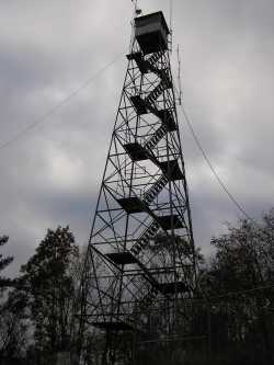
Springdale
Waypoint: CLT002 36.4376,-83.5053
County: Claiborne
Elevation: 2300'
Info: GA3532 2-7 standing
popup list of
nearby towers (mileage, bearing)
or
nearby landforms
MAPS
Select one of the following maps to display this waypoint (WGS84).
GPS
Remarks:
 weather at the tower
Tennessee lookout towers

BSF landforms (TN/KY)
GSMNP landforms (TN/NC)
Tennessee landforms
home
arches
waterfalls
rocks
peaks
balds
sinks
lakes
regions
county
 ©
Tom Dunigan
©
Tom Dunigan