TN leaflet map
marker:
Find
Enter street,city,state or zip code or lat,-lon (dd.ddd)
this )
Delete Last Point
Clear Track
left click on map to make a track
Save Track
this button will popup a window from which you can save the track as a
file.gpx for uploading to your GPS.
Plot track elevation profile
-- google elevations (10m DEM) and area (acres)
track elevation profile
-- courtesy of
heywhatsthat.com (30m SRTM)
Select county
Anderson
Bedford
Benton
Bledsoe
Blount
Bradley
Campbell
Cannon
Carroll
Carter
Cheatham
Chester
Claiborne
Clay
Cocke
Coffee
Crockett
Cumberland
Davidson
Decatur
DeKalb
Dickson
Dyer
Fayette
Fentress
Franklin
Gibson
Giles
Grainger
Greene
Grundy
Hamblen
Hamilton
Hancock
Hardeman
Hardin
Hawkins
Haywood
Henderson
Henry
Hickman
Houston
Humphreys
Jackson
Jefferson
Johnson
Knox
Lake
Lauderdale
Lawrence
Lewis
Lincoln
Loudon
Macon
Madison
Marion
Marshall
Maury
McMinn
McNairy
Meigs
Monroe
Montgomery
Moore
Morgan
Obion
Overton
Perry
Pickett
Polk
Putnam
Rhea
Roane
Robertson
Rutherford
Scott
Sequatchie
Sevier
Shelby
Smith
Stewart
Sullivan
Sumner
Tipton
Trousdale
Unicoi
Union
Van_Buren
Warren
Washington
Wayne
Weakley
White
Williamson
Wilson
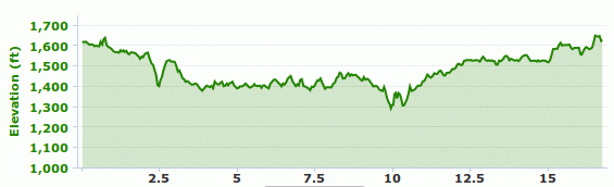
Rock Creek/John Muir trails and Chestnut Ridge
A 17-mile figure-8 loop starting on Divide Rd, then down to Rock Creek
trailhead. Mostly single-track with about 5 miles of gravel and
a 1100' cumulative climb.
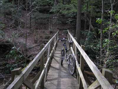
Massey Branch bridge
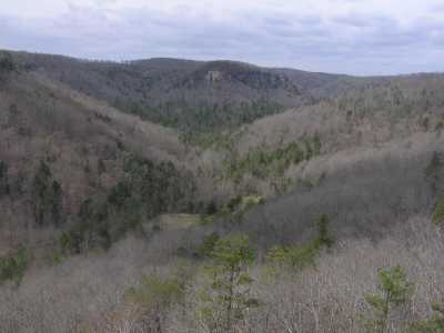
view from No Business overlook
leafletjs.com
TODO testing leafletjs
caltopo shaded layer
numbered pins
geolocate
PoI and move map, fickle mouseover? ok with marker vs circlemarker,
but xhair drift, center drift on zoom ??
landforms
GSMNP landforms
BSF landforms
AT shelters
TNlandforms.US