 Photo by Gregory Plumb, Author of
Waterfalls of Tennessee
Photo by Gregory Plumb, Author of
Waterfalls of Tennessee
| WGS84 | |
| 36.374400 | -82.305700 |
| 36° 22.464'N | 82° 18.342'W |
| 36° 22' 27.8"N | 82° 18' 20.5"W |
| 17S 382876E 4026268N | |
| convert to NAD27 | |
MAPS
Select one of the following maps to display this waypoint (WGS84).
GPS
Remarks:
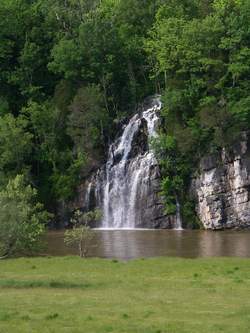
Reference: Bill Stowell
Reportedly this waterfall owes its existence to the pumping out of groundwater seeping into a quarry above and just to the north of this locale.
Photo by Gregory Plumb, Author of
Waterfalls of Tennessee