Tennessee Landforms -- waterfalls| WGS84 |
| 35.857464 | -85.629936 |
| 35° 51.448'N | 85° 37.796'W |
| 35° 51' 26.9"N | 85° 37' 47.8"W |
| 16S 623706E 3969006N |
| convert to NAD27 |
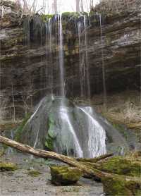
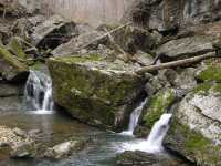
Cliff Creek Falls 30'
Waypoint: WHF022 35.857464,-85.629936
County: White landforms of White county
Locale: CenterHill
popup list of
nearby landforms (mileage, bearing)
MAPS
Select one of the following maps to display this waypoint (WGS84).
GPS
Remarks:
Several wet weather falls along Cliff Creek.
Tennessee landforms
home
arches
waterfalls
rocks
peaks
balds
sinks
lakes
regions
county
GSMNP landforms (TN/NC)
BSF landforms (TN/KY)
or nearby
lookout towers
Chuck Sutherland's www.tnlandforms.com the future (2024)
 ©
Tom Dunigan
©
Tom Dunigan