Tennessee Landforms -- waterfalls| WGS84 |
| 35.943108 | -85.451941 |
| 35° 56.586'N | 85° 27.116'W |
| 35° 56' 35.2"N | 85° 27' 7"W |
| 16S 639628E 3978746N |
| convert to NAD27 |
Waterfall Cave Falls 5'
Waypoint: WHF016 35.943108,-85.451941
County: White landforms of White county
Locale: private
popup list of
nearby landforms (mileage, bearing)
MAPS
Select one of the following maps to display this waypoint (WGS84).
GPS
Remarks:
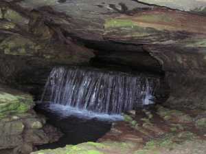
small falls in cave entrance empties into Calfkiller River.
Tennessee landforms
home
arches
waterfalls
rocks
peaks
balds
sinks
lakes
regions
county
GSMNP landforms (TN/NC)
BSF landforms (TN/KY)
or nearby
lookout towers
Chuck Sutherland's www.tnlandforms.com the future (2024)
 ©
Tom Dunigan
©
Tom Dunigan