Tennessee Landforms -- waterfalls| WGS84 |
| 35.818700 | -85.663400 |
| 35° 49.122'N | 85° 39.804'W |
| 35° 49' 7.3"N | 85° 39' 48.2"W |
| 16S 620743E 3964664N |
| convert to NAD27 |
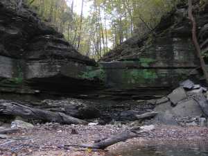
Klaylee Falls 7'
Waypoint: WAF002 35.818700,-85.663400
County: Warren landforms of Warren county
Locale: park
popup list of
nearby landforms (mileage, bearing)
MAPS
Select one of the following maps to display this waypoint (WGS84).
GPS
Remarks:
wet-weather falls in Warren County Park that empties into Center Hill.
Tennessee landforms
home
arches
waterfalls
rocks
peaks
balds
sinks
lakes
regions
county
GSMNP landforms (TN/NC)
BSF landforms (TN/KY)
or nearby
lookout towers
Chuck Sutherland's www.tnlandforms.com the future (2024)
 ©
Tom Dunigan
©
Tom Dunigan