Tennessee Landforms -- waterfalls| WGS84 |
| 36.220700 | -83.764400 |
| 36° 13.242'N | 83° 45.864'W |
| 36° 13' 14.5"N | 83° 45' 51.8"W |
| 17S 251518E 4011971N |
| convert to NAD27 |
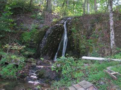
Fallen Water Falls 14'
Waypoint: UNF001 36.220700,-83.764400
County: Union landforms of Union county
Locale: private
popup list of
nearby landforms (mileage, bearing)
MAPS
Select one of the following maps to display this waypoint (WGS84).
GPS
Remarks:
Reference: Kevin Baker
music festival
Tennessee landforms
home
arches
waterfalls
rocks
peaks
balds
sinks
lakes
regions
county
GSMNP landforms (TN/NC)
BSF landforms (TN/KY)
or nearby
lookout towers
Chuck Sutherland's www.tnlandforms.com the future (2024)
 ©
Tom Dunigan
©
Tom Dunigan