Tennessee Landforms -- waterfalls| WGS84 |
| 35.778572 | -83.674056 |
| 35° 46.714'N | 83° 40.443'W |
| 35° 46' 42.8"N | 83° 40' 26.6"W |
| 17S 258294E 3962688N |
| convert to NAD27 |
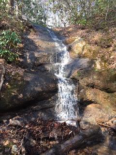
Mountain Falls
Waypoint: SVF054 35.778572,-83.674056
County: Sevier landforms of Sevier county
Locale: private
popup list of
nearby landforms (mileage, bearing)
MAPS
Select one of the following maps to display this waypoint (WGS84).
GPS
Remarks:
Reference and photo: Keith Garnes
Tennessee landforms
home
arches
waterfalls
rocks
peaks
balds
sinks
lakes
regions
county
GSMNP landforms (TN/NC)
BSF landforms (TN/KY)
or nearby
lookout towers
Chuck Sutherland's www.tnlandforms.com the future (2024)
 ©
Tom Dunigan
©
Tom Dunigan