Tennessee Landforms -- waterfalls| WGS84 |
| 35.713103 | -83.336599 |
| 35° 42.786'N | 83° 20.196'W |
| 35° 42' 47.2"N | 83° 20' 11.8"W |
| 17S 288629E 3954645N |
| convert to NAD27 |
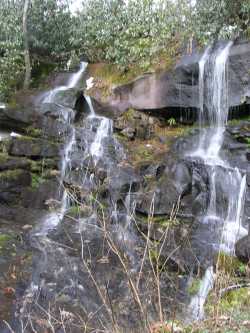
Ramsay Branch Falls 30'
Waypoint: SVF050 35.713103,-83.336599
County: Sevier landforms of Sevier county
Locale: Great Smoky Mountains National Park
popup list of
nearby landforms (mileage, bearing)
MAPS
Select one of the following maps to display this waypoint (WGS84).
GPS
Remarks:
Reference: gk
cascades downstream from falls
Tennessee landforms
home
arches
waterfalls
rocks
peaks
balds
sinks
lakes
regions
county
GSMNP landforms (TN/NC)
BSF landforms (TN/KY)
or nearby
lookout towers
Chuck Sutherland's www.tnlandforms.com the future (2024)
 ©
Tom Dunigan
©
Tom Dunigan