Tennessee Landforms -- waterfalls| WGS84 |
| 35.635800 | -83.586600 |
| 35° 38.148'N | 83° 35.196'W |
| 35° 38' 8.9"N | 83° 35' 11.8"W |
| 17S 265783E 3946636N |
| convert to NAD27 |
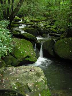
Jakes Creek Cascades
Waypoint: SVF045 35.635800,-83.586600
County: Sevier landforms of Sevier county
Locale: Great Smoky Mountains National Park
popup list of
nearby landforms (mileage, bearing)
MAPS
Select one of the following maps to display this waypoint (WGS84).
GPS
Remarks:
Numerous cascades along Jakes Creek trail, above and below the waypoint.
Tennessee landforms
home
arches
waterfalls
rocks
peaks
balds
sinks
lakes
regions
county
GSMNP landforms (TN/NC)
BSF landforms (TN/KY)
or nearby
lookout towers
Chuck Sutherland's www.tnlandforms.com the future (2024)
 ©
Tom Dunigan
©
Tom Dunigan