Tennessee Landforms -- waterfalls| WGS84 |
| 35.598200 | -83.500900 |
| 35° 35.892'N | 83° 30.054'W |
| 35° 35' 53.5"N | 83° 30' 3.2"W |
| 17S 273439E 3942264N |
| convert to NAD27 |
Meigs Post Falls 13'
Waypoint: SVF014 35.598200,-83.500900
County: Sevier landforms of Sevier county
Locale: Great Smoky Mountains National Park
popup list of
nearby landforms (mileage, bearing)
MAPS
Select one of the following maps to display this waypoint (WGS84).
GPS
Remarks:
off-trail.
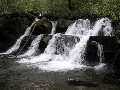
further upstream is Wilson Falls
Tennessee landforms
home
arches
waterfalls
rocks
peaks
balds
sinks
lakes
regions
county
GSMNP landforms (TN/NC)
BSF landforms (TN/KY)
or nearby
lookout towers
Chuck Sutherland's www.tnlandforms.com the future (2024)
 ©
Tom Dunigan
©
Tom Dunigan