Tennessee Landforms -- waterfalls| WGS84 |
| 35.662210 | -83.620130 |
| 35° 39.733'N | 83° 37.208'W |
| 35° 39' 44"N | 83° 37' 12.5"W |
| 17S 262824E 3949647N |
| convert to NAD27 |
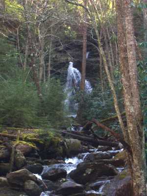
Mannis Branch Falls 30'
Waypoint: SVF013 35.662210,-83.620130
County: Sevier landforms of Sevier county
Locale: Great Smoky Mountains National Park
popup list of
nearby landforms (mileage, bearing)
MAPS
Select one of the following maps to display this waypoint (WGS84).
GPS
Remarks:
Dana's trip report
Tennessee landforms
home
arches
waterfalls
rocks
peaks
balds
sinks
lakes
regions
county
GSMNP landforms (TN/NC)
BSF landforms (TN/KY)
or nearby
lookout towers
Chuck Sutherland's www.tnlandforms.com the future (2024)
 ©
Tom Dunigan
©
Tom Dunigan