Tennessee Landforms -- arches and natural bridges| WGS84 |
| 35.610000 | -83.430200 |
| 35° 36.6'N | 83° 25.812'W |
| 35° 36' 36"N | 83° 25' 48.7"W |
| 17S 279877E 3943412N |
| convert to NAD27 |
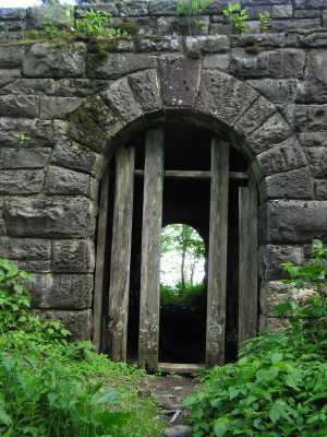
Newfound Tunnel 7x12
Waypoint: SVA006 35.610000,-83.430200
County: Sevier landforms of Sevier county
Locale: Great Smoky Mountains National Park
NABSQNO 17S-279877-3943412
popup list of
nearby landforms (mileage, bearing)
MAPS
Select one of the following maps to display this waypoint (WGS84).
GPS
Remarks:
Man-made passage under road to Clingman's Dome, presumably
intended to let horses pass under the road, but the old trails
(see topo map) are no longer in use.
(Or a secret border crossing between Tennessee and North Carolina :-)
Why the tunnel?
Also see old Dutch Roth
black&white
Tennessee landforms
home
arches
waterfalls
rocks
peaks
balds
sinks
lakes
regions
county
GSMNP landforms (TN/NC)
BSF landforms (TN/KY)
or nearby
lookout towers
Chuck Sutherland's www.tnlandforms.com the future (2024)
 ©
Tom Dunigan
©
Tom Dunigan