Tennessee Landforms -- arches and natural bridges| WGS84 |
| 35.832600 | -83.477900 |
| 35° 49.956'N | 83° 28.674'W |
| 35° 49' 57.4"N | 83° 28' 40.4"W |
| 17S 276180E 3968216N |
| convert to NAD27 |
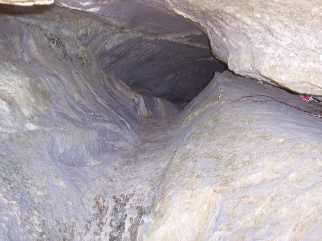
Red Bank Tunnel 4x3
Waypoint: SVA005 35.832600,-83.477900
County: Sevier landforms of Sevier county
NABSQNO 17S-276180-3968216
popup list of
nearby landforms (mileage, bearing)
MAPS
Select one of the following maps to display this waypoint (WGS84).
GPS
Remarks:
Reference & photo: Keith Garnes
75' natural bridge along Little Pigeon River
Tennessee landforms
home
arches
waterfalls
rocks
peaks
balds
sinks
lakes
regions
county
GSMNP landforms (TN/NC)
BSF landforms (TN/KY)
or nearby
lookout towers
Chuck Sutherland's www.tnlandforms.com the future (2024)
 ©
Tom Dunigan
©
Tom Dunigan