Tennessee Landforms -- arches and natural bridges| WGS84 |
| 35.855560 | -83.470670 |
| 35° 51.334'N | 83° 28.24'W |
| 35° 51' 20"N | 83° 28' 14.4"W |
| 17S 276897E 3970747N |
| convert to NAD27 |
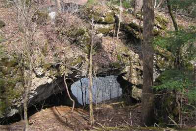
East Fork Arch 25x18
Waypoint: SVA003 35.855560,-83.470670
County: Sevier landforms of Sevier county
Locale: private
NABSQNO 17S-276897-3970747
popup list of
nearby landforms (mileage, bearing)
MAPS
Select one of the following maps to display this waypoint (WGS84).
GPS
Remarks:
Reference: Keith Garnes
Not far off of Arch Rock Drive, but on the south side of the creek. private.
The
Harrisburg covered bridge is nearby.
Tennessee landforms
home
arches
waterfalls
rocks
peaks
balds
sinks
lakes
regions
county
GSMNP landforms (TN/NC)
BSF landforms (TN/KY)
or nearby
lookout towers
Chuck Sutherland's www.tnlandforms.com the future (2024)
 ©
Tom Dunigan
©
Tom Dunigan