Tennessee Landforms -- waterfalls| WGS84 |
| 36.508500 | -82.611730 |
| 36° 30.51'N | 82° 36.704'W |
| 36° 30' 30.6"N | 82° 36' 42.2"W |
| 17S 355671E 4041559N |
| convert to NAD27 |
Dolan Branch Falls 20'
Waypoint: SUF001 36.508500,-82.611730
County: Sullivan landforms of Sullivan county
Locale: park
popup list of
nearby landforms (mileage, bearing)
MAPS
Select one of the following maps to display this waypoint (WGS84).
GPS
Remarks:
CNF trail 50
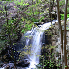 Dave Aldridge photo
Tennessee landforms
home
arches
waterfalls
rocks
peaks
balds
sinks
lakes
regions
county
GSMNP landforms (TN/NC)
BSF landforms (TN/KY)
or nearby
lookout towers
Chuck Sutherland's www.tnlandforms.com the future (2024)
 ©
Tom Dunigan
©
Tom Dunigan