Tennessee Landforms -- waterfalls| WGS84 |
| 36.308000 | -85.947000 |
| 36° 18.48'N | 85° 56.82'W |
| 36° 18' 28.8"N | 85° 56' 49.2"W |
| 16S 594536E 4018625N |
| Location uncertain. |
| convert to NAD27 |
Bearwaller Falls? 20'
Waypoint: SMF001 36.308000,-85.947000
County: Smith landforms of Smith county
Locale: Cordell Hull
popup list of
nearby landforms (mileage, bearing)
MAPS
Select one of the following maps to display this waypoint (WGS84).
GPS
Remarks:
Reference: Kevin Baker, and this narrative
wet-weather falls along
Bearwaller Gap trail
of alltrails
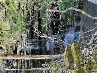 Fife photo
Tennessee landforms
home
arches
waterfalls
rocks
peaks
balds
sinks
lakes
regions
county
GSMNP landforms (TN/NC)
BSF landforms (TN/KY)
or nearby
lookout towers
Chuck Sutherland's www.tnlandforms.com the future (2024)
 ©
Tom Dunigan
©
Tom Dunigan